The Highest Peaks in Dumfries & Galloway
11 Aug 2021Although Dumfries and Galloway doesn’t immediately come to many people when considering hill walking in Scotland, there are a considerable number of summits within the region which offer anything from a long or strenuous walk, to challenging and, occasionally, dangerous terrain.
Hill walking should never be undertaken lightly. Forward planning and knowledge, including familiarising yourself with the route, transport and provisions, as well as ensuring you have the correct equipment for all outcomes, is essential however, if you do know what you’re doing and you’re looking for somewhere off the beaten track to get a few miles and trig points under your belt, Dumfries and Galloway will certainly deliver.
Here you will find information and further reading about some of the highest peaks in the region.
- Wigtownshire
The highest summit in the region is the Merrick. Rising to 843m, the hill is classed as a Corbett and is located beside Loch Trool, roughly 15 miles from Newton Stewart. Part of the fantastically named Range of the Awful Hand, which straddles both Dumfries and Galloway and South Ayrshire, the terrain is a mix of crag, tussock and bog on the ascent, with short grass coverage to the flatter ground.
There are two popular routes up the Merrick. The shortest, and most commonly undertaken, leaves the Bruce’s Stane car park (the stone is a monument commemorating the victory of Robert the Bruce over Edward II English forces in the Battle of Glen Trool, fought in the area in 1307) before turning left and following the path towards the recently restored Culsharg Bothy. From there the path climbs through forestry and up subsidiary summit Benyellary (719m) before the final ascent to the trig point of the Merrick is made.

On the western ridge of the hill, at roughly 800m, there are a number of partially buried granite boulders. Interestingly, although they are without a doubt glacial erractics, it is unclear how they came to be deposited so close to the summit. By far the most popular rocky feature of the hill however is the Grey Man Of Merrick, visible along the second ascent, via Loch Valley.
This is a circular route accessed not via the signposted route but by continuing along the main track beyond the car park, over Buchan Burn, before turning left towards Gairland Burn and Loch Valley. The way is very boggy, but the effort is rewarded with fantastic views over Loch Trool and, eventually, Loch Neldricken and the Murder Hole, Loch Arron and Loch Enoch. From here the path ends but the route becomes drier under foot as it ascends the Rig of Ennoch. Just before the highest point on this ridge, the craggy Grey Man of Merrick can be seen to the left. Walkers then ascend Redstone Rigg and on to the summit.
On a clear day, walkers can expect to look out over the South Ayrshire coast to Ailsa Craig, and on to the Isle of Arran and Goat Fell, and even Ireland on a clear day. In the opposite direction and under the right conditions, ie snow capped peaks for contrast, it is technically possible to see Snowdon from the summit of the Merrick. This is the longest line of sight in the British Isles at 144m.

Technically the most southerly mountain in Scotland, Cairnsmore of Fleet is the highest of the Solway Hills and, at 711m, is classed as a Graham. A somewhat sprawling granite massif, the slopes, summit, two subsidiaries (the Knee of Cairnsmore and Meikle Mulltaggart) and the moorland area surrounding the hill (the most extensive area of moorland in Galloway) are part of the Cairnsmore of Fleet National Nature, a designated Site of Special Scientific Interest. The terrain is mainly grassland therefore, though the summit is quite rocky in places. Much like the Merrick, there are two main routes of ascent up Cairnsmore. The most popular starts in the south-west, from a car park near Stronord, just 2 miles from Newton Stewart. It follows a road through part of the Cairnsmore Estate before diagonally crossing a field and on to a rocky paths which climbs through Bardrochwood Moor Wood, passed a memorial seat for Rosemary Pilkington, responsible for the surrounding forestry plantations, across a forestry road and on up to the summit. It’s a fairly straightforward, easy going route, occasionally boggy in areas, which offers breathtaking views over the Cree Estuary, southern Galloway and on to the Solway Firth and Isle of Man.
A more challenging ascent of Cairnsmore can be undertaken from Dromore and the Big Water of Fleet Viaduct, near Creetown. Parking on the far side of the viaduct, walkers continue along forestry a forestry road, keeping to the left and on passed a number of small quarries. Once the road ends, the route crosses a boggy section of grassland known as the Door of Cairnsmore, over Cardoun Burn and on to the steeper slopes that lead to the summit of the Knee of Cairnsmore. From this point, the track up to the summit of Cairnsmore is faint, especially in the wetter areas near to the lochans. The summit itself has a number of features including a cairn, the trig point and a memorial to 25 airmen killed when their various planes crashed into the hill during poor visibility.
Again, like the Merrick, once on the summit of Cairnsmore, walkers can extend the walk by proceeding across to subsidiary summit Meikle Mulltaggart, on to Craigronald and even the Clints of Dromore but caution should be taken as the going is pathless, wet and long. Alternatively, approx. 900m north west of the summit of Cairnsmore is Billy Marshall’s Cave, a large boulder cave, reputedly used for storing smuggled goods like salt and rum, brought ashore at nearby Carsluith. Though hard to find, the cave makes for an interesting detour and is marked by an iron bar protruding from the opening.
Unsurprisingly, being a nature reserve, there is much to see around Cairnsmore including peregrine falcons and hen harriers, the occasional golden eagle, wild goats and red deer, as well as 17 species of butterfly, 120 species of moth and the nationally notable golden green ground beetle.
- Moffat
As the first town in Scotland to be awarded ‘Walkers are Welcome’ status, it’s no surprise that Moffat and the surrounding hills offer rich pickings to walkers of all abilities. A great number of local walks even begin in the town centre, allowing holiday makers to leave cars behind and set off from their accommodation however, for the ascent up Dumfries and Galloway’s 2nd highest peak, White Coombe (821m) a 20 minute car journey out of town is necessary.
Carved out by glaciers during the Quaternary Ice Age (the last 2.6 million years) the area is impressively dramatic, breathtakingly beautiful and a geologist’s dream. Conveniently, the ascent up White Coomb incorporates three of the areas very best spectacles. The Grey Mare’s Tail waterfall, the 5th highest in the UK, flows over a series of cascades and pools, before finally plunging 61m into Moffatdale, each step created by variations in erosional resistance.
Above the waterfall, and feeding it, is Loch Skeen. Deep and cold, the loch is surrounded by a collection of ridges and hummocks, made up of gravel, sand and silt, known as morraines and caused by the changing positions of glacial margins.
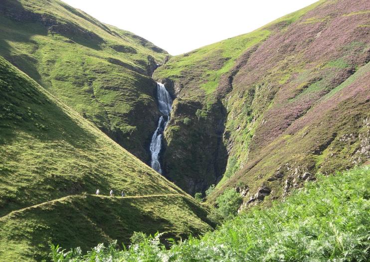
Despite these features, the route up the 3rd spectacle, White Coomb itself, is initially straightforward, following steeply ascending stairs which skirt the north side of the waterfall, and then along a rough path towards the loch. Once the head of Loch Skeen is reached, walkers must cross the fast flowing Tail Burn, before taking a well worn trail up Upper Tarnberry and on to the east ridge which leads to the summit of White Coomb. A moated cairn, thought to be bronze age in origin, marks the highest point.
White Coomb is surrounded by hills of varying sizes, so extending this walk is relatively easy. One route can incorporate several neighbouring peaks including Firthhope Rig (800m), Donald’s Cleuch Head (776m), Molls Cleuch Dod (785m) and Lochcraig Head (801m). A truly epic walk, of over 15m, can also be undertaken from Blackhope, heading up Swatte Fell (730m) then Hart Fell (808m), over to Under Saddle Yolk (745m) and finishing with White Coomb, but it’s tough going and pathless in many areas.
To the north of Moffat is the Devil’s Beef Tub, a deep and dramatic hollow formed by the four hills Great Hill (774m), Peat Knowe, Annanhead Hill (478m) and Ericstane Hill (477m.) It is one of the two main sources of the River Annan, the other being neighbouring Hart Fell. The unusual names derives from the days when the area was used by Border Reivers to hide their ill gotten gains, usually cattle. Their enemies dubbed them ‘devils’ that hid the stolen cattle in the hollow or ‘tub.’

The deep bowl of the Tub can be reached by walking up and over Ericstane Hill, however a circuit of 14 miles takes in three of the afore mentioned peaks and starts from the Station car park in Moffat. The start of the trail is reasonably well signposted, as it forms the first part of the Annandale Way, though the first official marker to this route is located on Annandale Head. Walkers follow the east bank of the River Annan, across the A701, over fields and along roads until it reaches Meikleholmside. From there, the route crosses the river and open pastureland before entering a plantation and ascending Ericstane Hill. Once over Ericstane, the A701 is followed north-westwards to the edge of another large plantation and a grassy path which eventually leads up Annandale Hill. The route then turns east and over to Peat Knowe, north of Great Hill, and across Chalk Rig Edge to Annandale Head. From this summit, walkers can look out over the surrounding hills and Annandale, to Tweedhope Byrn and a recently planted woodland of native saplings.
- Rhinns of Kells & Glenkens
The Rhinns of Kells is a 17km ridge accessed from the Forrest Estate, just off the A713 between Carsphairn and St John’s Town of Dalry, offering wonderful walking opportunities and stunning views.
At 814m Corserine, meaning Cross Ridge, is the highest point along the ridge, the third highest peak in Dumfries and Galloway and one of the six Corbetts within the region. From the north, west and south, the hill is made up of relatively straight forward grassy terrain however, the ascent is much more challenging from the south, along the southeast ridge, being steeper and and rocky in areas.
The Forrest Estate is owned by the Fred Olsen group and is run for commercial forestry and hydro electric. The tracks that crisscross the estate are named after Olsen family members and employees with 25+ years of service, which makes the initial stages of the ascent up Corserine easy enough to navigate but oddly like trying to find the way across town. Walkers should park at the public car park at Burnhead Bridge, head towards Forrest Lodge before forking left onto Birger Natvig Road/Core Path 154 and passed a whitewashed house at Fore Bush. Once passed the vehicle barrier, it’s right onto Robert Watson Road, straight across Anette Olsen Road, and on following ‘Hillwalker’ signs over Folk Burn. A newly constructed path is then followed before a grassy path continues onto the open hillside and on to the summit. Just north west of the summit, the scars of an old plane crash can still be seen.
Once at the top, it’s a simple case of retracing your steps back to the car park however, by heading south east, the walk can be extended along the ridge, taking in Millfire (716m) Milldown (738m) and Meikle Millyea (748m.)

Just 15 minutes from Corserine and the Forrest Estate are the Carsphairn and Scaur Hills, the highest summit of which is Cairnsmore of Carsphairn, sometimes known as Cairnsmore of Deugh. Of the three Cairnsmores in Dumfries and Galloway (Cairnsmore of Fleet, Dee & Carsphairn) this grassy hill is actually the highest, at 797m, and therefore classed as a Corbett, but is probably the easiest climb of all the peaks mentioned here, with a short ascent and flat summit rewarded with excellent views. It does involve ascending the three smaller foothills of Willieanna (420m), Dunool (541m) and Black Shoulder (688m) first however, but the stunning views along the way, over the surrounding hills and the Galloway and Southern Ayrshire Biosphere, more than make up for the effort.

The walk begins a mile or so north of Carsphairn Village, at Green Well of Scotland, along the A713. A signposted core path directs walkers down a newly constructed track opposite Bridge End. Keeping left upstream of the Water of Deugh river, then crosses Benloch Burn, before cotinuing up the glen. Once alongside the first foothill, Willieanna, it’s really a case of striking off at a suitable point and continuing, pathless, to the summit of this rounded hill before following a drystone wall to the left and up the much steeper Dunool.
At this point it’s possible to look back towards Corserine and the Rhinns of Kells before continuing on over Blackshoulder and up to the summit of Cairnsmore of Carsphairn, marked by a cairn and the usual trig point. Like most of the peaks in Dumfries and Galloway, once at the top, it’s possible to see down to the Solway, and northwest to Ayr, Arran and Ailsa Craig. Generally this walk takes about 3 hours, but can be extended by combining the subsidiary summit of Beninner (710m.)
- Dumfriesshire
A prominent feature in the landscape around Dumfries due to it’s isolated position, Criffel is actually smaller than the other main peaks mentioned here, at 570m. The views across the Solway aforded by climbing this hill are unmatched however, and make it a worthy inclusion. The etymology of the name Criffel is fascinating, with many theories including Old Norse, Icelandic and Gaelic origins, ranging in meaning from boundary or split, to ‘raven’s or crow’s hill.’ Certainly ravens are often seen from the higher ground, as are red grouse and, occasionally, adders during warmer months.
The terrain features upland vegetation like blaeberry, bog cotton and heather and, once boggy towards the summit, has been vastly improved by a recent path upgrade. The most direct route to the summit is via the Ardwall path but a fantastic circular route from New Abbey means walkers can incorporate a visit to the Abbey Arms Hotel or Abbey Cottage Tearoom at the end of their walk. The Ardwall route begins at the end of an unsigned minor road to Ardwall, where a kissing gate and Public Path sign mark the way. The new path then climbs through recently planted native woodland, with the Craigrockall Burn to the right. Later, walkers should ignore a footbridge and stay on the main path until the top edge of the forestry is reached. From this point, the new path bears left, before flattening out towards the summit. A large cairn, Douglas’s Cairn, and the usual trig point mark the highest point. The main thing to remember at this point is to stop and take in the views of the Solway Firth. To the west (east when facing England) lies the Nith Estuary, whilst across the water, it’s possible to see the Lake District, with Skiddaw being the most prominent peak.

Whilst the hills above represent some of the highest peaks in Dumfries and Galloway, there are a few other intriguing summits in the region, worth devoting some time to whilst on holiday.
With its wide, flat top, Burnswark Hill is one of the most prominent features in the landscape between Ecclefechan and Locherbie, despite being just over 300m high. It is the complex history of this hill, not the height which makes it special however. The summit was once home to an Iron Age hill-fort measuring an enclosed area of approximately 7ha, but evidence of an earlier Bronze Age burial cairn, Roman camps and a possible fortlet, enclosures dating to the medieval period, and a possible Civil War battery have also been found, make it an intriguing place to say the least. Then there’s Lowther Hill (725m) which lies east of the town of Sanquhar, on the border between Dumfries & Galloway and Lanarkshire. Its summit is topped by a National Air Traffic Services radar station, known locally at ‘the golf ball.

‘For a real challenge, the summits of Benbrack (581m), Colt Hill (598m) and Bail Hill near Cairnhead, Moniaive, are home to three Striding Arches, built by the renowned landscape artist Andy Goldsworthy. Made from red sandstone sourced from nearby Dumfries, the structures are 4 meters high, span 7 meters across and consist of 31 blocks weighing 27 tons. It is possible to walk between Benbrack and Colt Hill, visiting 2 of the 3 arches in one go. The walk begins at a small parking area at Cairnhead. Just beyond this car park is a 4th arch which strides through an old renovated Byre. Though the three arches are linked by sight-lines, Bail Hill is much further down the valley towards Moniaive, and entirely pathless, so the 3rd arch is only really accessible to keen walkers.
By now it will be obvious that Dumfries and Galloway offers some fantastic walking and hiking opportunities. Walking doesn’t have to be about how high or how far you walk, but how much you enjoy yourself along the way. These hills are a joy to explore and should be seen as equal to those found in the Highlands or Islands of Scotland.
Why not browse our cottages in the region, book yourself a holiday and come and see for yourself? For a list of local retailers specialising in outdoor clothing and equipment click here.